I was enjoying the cultural splendours of St Petersburg when the devastating tsunami of December 2004 hit. Since the only source of information that CNN news could present to us was their weather-person, I became, as the token geologist in our tour group, responsible for passing on what I knew and correcting media inaccuracies. The anniversary of that appalling event is now approaching, and there are several reports currently in the geo-news of the ongoing forensic work on the earthquake and the tsunami. Workers at Caltech have established that the 2004 and subsequent events only released stress along particular segments of the subduction zone (for example, the build-up since the major earthquake of 1861), and that other areas remain stressed and liable to rupture in the not-too-distant future. “From what we saw,” says geologist Jean-Philippe Avouac, director of the Tectonics Observatory and one of the paper’s lead authors, “we can say with some confidence that we’re probably not done with large earthquakes in Sumatra.” (http://www.sciencedaily.com/releases/2008/12/081203131042.htm). And, just to emphasize the continuing surprises that our planet has for us (i.e. the things that make geology exciting), research at the University of Washington has shown that the 2004 Sumatra earthquake triggered low-level seismic events along the San Andreas fault: “We found that an earthquake that happened halfway around the world could trigger a seismic signal in the San Andreas fault. It is a low-stress event and a new kind of seismic phenomenon,” said Abhijit Ghosh, a University of Washington doctoral student in Earth and space sciences. (http://www.eurekalert.org/pub_releases/2008-12/uow-gio121008.php and read more at Andrew Alden’s great portal to all things geological at http://geology.about.com/b/2008/12/11/triggered-tremor-from-half-a-world-away.htm).
But this is a blog about sand - where is all this seismology stuff leading? In order to have any hope of avoiding the tragedy of the 2004 event in the likely future earthquakes, a combination of approaches is needed. Prediction with sufficient accuracy remains out of the question, but the development of the Indian Ocean Tsunami Warning System (IOTWS) is vital, and the design and effectiveness of this  system depends on our understanding of the character and timing of past tsunamis - hence the forensics. On an island just off the coast of Aceh most people safely fled to higher ground in 2004 because the island’s oral history includes information about a devastating tsunami in 1907.
When you look at the “before and after” images of the Aceh coast, and if you can think beyond the scale of the human tragedy, one obvious question is “where have the beaches gone?” The upper image shows the answer - strewn for long distances inland. (Images credit Ikonos images copyright Centre for Remote Imaging, Sensing and Processing, National University of Singapore and Space Imaging, see http://www.nasa.gov/vision/earth/lookingatearth/indonesia_quake.html). These deposits give us vast amounts of information about tsunamis past and present. The photo below shows a cross-sectional .
.
The layers of sand swept inland by historic tsunamis provide a crucial historic and geologic record. Although destructive tsunamis are rather rare events at a given coastal location, to estimate the existing tsunami hazard properly, long-term observations are required. Geologic records of pre-historical tsunamis can extend the historical and instrumental records to the recent past and fill in gaps in the historic and geographic records. An international team, supported by the US IOTWS program, and led by Kruawun Jankaew of Chulalongkorn University in Thailand, have been digging hundreds of pits at locations in Thailand and Sumatra to reveal this record, and have recently reported their results (http://www.sciencedaily.com/releases/2008/10/081029141037.htm). The photo shows Dr. Kruawun in one of these excavations. The pit reveals a regular sequence of sand layers interrupting the normal dark soils - the topmost layer is the sand deposited by the 2004 tsunami, the lower ones successively older events over the last few thousand years. Radiocarbon dating of bark fragments in soil below the second sand layer led the scientists to estimate that the most recent predecessor to the 2004 tsunami probably occurred between A.D. 1300 and 1450 and there is clear evidence of two earlier tsunamis during the last 2,500 to 2,800 years.
The knowledge gained from this work contributes to an effective warning system and tsunami education. In the words of Dr. Kruawun, “Many people in Southeast Asia, especially in Thailand, believe, or would like to believe, that it will never happen again. This will be a big step towards mitigating the losses from future tsunami events.”
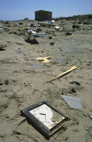
So, I guess that the message here is that sand can help save lives. I shall end this post with what I think is a poignant and provocative image. this time from the sands left by a tsunami that devastated the Japanese island of Okushiri in 1993. A clock, half-buried in the sand, provided one small piece of timing data for the event (http://www.ngdc.noaa.gov/nndc/struts/results?eq_1=27&t=101634&s=0&d=4&d=44).
Comments
The image of Dr. Kruawun, what do the altering colors of the stick measure - time scale? - how much time?
Fantastic pictures, I recall seeing something similar on the discovery channel (or network of channels) where they were doing the same in the coastal areas of New England/New York (though I think it was more related to hurricane surge).
Jesse - thanks for the comment and for looking at my blog!
I believe that the stick is a meter measure and that each segment is 10 cms. It’s amazing how regular the sand occurrences are and how similar they are in thickness. As for time, the dark soil layers represent a long period of time, the sands an essentially instantaneous event; it looks as if the recent soil layer is around 20 cms thick and that represents the time since the last tsunami around seven or eight hundred years ago.
And yes, there’s a whole science of “paleotempestology” which looks at the sedimentary records of ancient storms and hurricanes - as well as tsunamis - and a lot of this kind of work has been done around all the coastal regions of the US.